Franconia Notch State Park is located in the heart of the White Mountain National Forest in New Hampshire. Franconia Notch (elev. 1,950 feet/590 m) itself is a major mountain pass through the White Mountains of New Hampshire extending from the Flume Gorge at the south to Echo Lake at the north.
The concept of a “notch” may be foreign to some. Was it the same as a mountain “pass” out west? If so, why not just call it a “pass?”
There are a number of explanations for the term, some saying it’s simply smaller than a mountain pass because the mountains through which it traverses are not as high. Other explanations assert the term comes from the fact a notch is literally like a notch in a log – a sharply V-shaped passage.
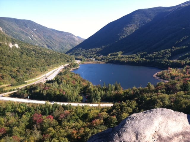
View of Echo Lake and Franconia Notch looking south from Artist’s Bluf
Regardless of the specific term, Franconia Notch is stunning. From the initial colonial explorers, to the painters of the Hudson River School, to the present-day hikers and tourists, it simply stirs the senses. And it starts miles away when you’re approaching from the south. It first appears almost mystical in the distance: the back side of Cannon Mountain. As you continue north you realize you’re continuing to ascend, ever so slightly.
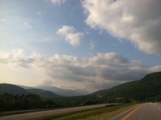
View from Interstate 93 driving north, with Franconia Notch far in the distance
Franconia Notch is bordered to the east by the Franconia Ridge, comprising Mount Lafayette (5,249 feet/1,600 m), Mount Lincoln (5,089 feet/1,551 m), and Little Haystack Mountain (4,780 feet/1,460 m), and to the west by Cannon Mountain (4,080 feet/1,240 m) and the sheer face of Cannon Cliff.
The notch is traversed by the Franconia Notch Parkway, Interstate 93 and U.S. Route 3. The parkway winds for 8 miles between the high peaks of the Kinsman and Franconia mountain ranges and required a special act of Congress to sidestep design standards for the Interstate highway system because it is only one lane in each direction.
The Old Man of the Mountain, a rock formation whose profile is a symbol of the state of New Hampshire, was located here until it collapsed in 2003. This was the same “Great Stone Face” immortalized by Nathaniel Hawthorne and Daniel Webster.
Echo Lake lies just north of the high point of the notch, with an outlet that flows into Lafayette Brook, then the Gale River, the Ammonoosuc River, and finally the Connecticut River, which enters Long Island Sound at Old Saybrook, Connecticut. Just south of the height of land, Profile Lake lies beneath the cliff that once held the Old Man of the Mountain. Profile Lake is the source of the Pemigewasset River, the primary tributary of the Merrimack River, which flows to the Gulf of Maine at Newburyport, Massachusetts.
The Flume Gorge & Visitor Center
Located within Franconia Notch State Park, the Flume is a natural gorge extending 800 feet at the base of Mount Liberty. The walls of Conway granite rise to a height of 70 to 90 feet and are 12 to 20 feet apart.
The Flume Visitor’s Center, framed by a spectacular vista of Mount Liberty and Mount Flume, houses the Flume ticket office, information center, cafeteria, gift shop, and the state park system’s historic Concord Coach. A 20-minute movie showcasing beautiful Franconia Notch State Park is available for viewing. The Flume Gorge opens for the season in early may and closes late October, weather permitting. There is an entrance fee.
The Basin. The beautiful waterfall at the Basin, has at its base, a granite pothole 20 feet in diameter. It is believed to have been eroded 15,000 years ago while the North American ice sheet was melting. It has been smoothed by small stones and sand whirled around by the Pemigewasset River. Below the Basin is a water-eroded rock formation called the Old Man’s foot.
Hiking
For more specific information, or for descriptions and maps of lengthier hikes into the White Mountain National Forest and on the Appalachian Trail, consult the Appalachian Mountain Club White Mountain Guide. It is important to wear sturdy walking shoes and remember that in the mountains weather changes suddenly and darkness falls quickly.